Salmonier to Cape Broyle
The first in a 3-part account of the author’s hike through one of the most remote parts of the Avalon Wilderness Reserve
I spent Labour Day weekend this year crossing the Avalon wilderness between Salmonier Line and Cape Broyle. My 50km route was mostly within the Avalon Wilderness Reserve, where some of the most isolated and inaccessible areas of country on the Avalon Peninsula are to be found. It is a place seldom seen by hikers, but very much worth the effort for those seeking an off-trail walking experience. I first ventured into the reserve as a teenager with my father in the mid-1990s. Since then, attracted by its striking landscapes and, more often than not, by the enticements of solitude, I’ve made a habit of going there for multi-day off-trail hikes. In the first three instalments of Wilderness Report, I’ll present an account of what I experienced during those three days en route from Salmonier to the Southern Shore.
I began walking shortly after noon on Saturday, after the heavy morning rains had ceased. An ATV trail located 17km down the Salmonier Line from the Trans Canada Highway, and running from the Salmonier Line to the Salmonier River at Pinsent’s Falls, provided me entry to the Avalon wilderness. The streams crossing this trail had been swollen by the night’s rains, making them difficult to ford without getting wet feet. About halfway along the trail a man on an ATV gave me a ride to the Salmonier River, saving me the trouble of crossing those unruly streams on foot. Arriving at the Salmonier River, I found it to be twice its normal depth at my usual fording place. The water came up to my hips and the current threatened to throw me, along with my heavy pack, into the water. With great relief, I made the crossing safely.
With that obstacle behind me I began my ascent out of the river valley so as to access the barrens and marshes in the high country above. The slope of the valley was well wooded. Well-grown birch trees appeared intermittently among the plentiful fir and spruce. I passed through large sections of windfall where walking was tricky over one dead tree after another.
Onto the Barrens
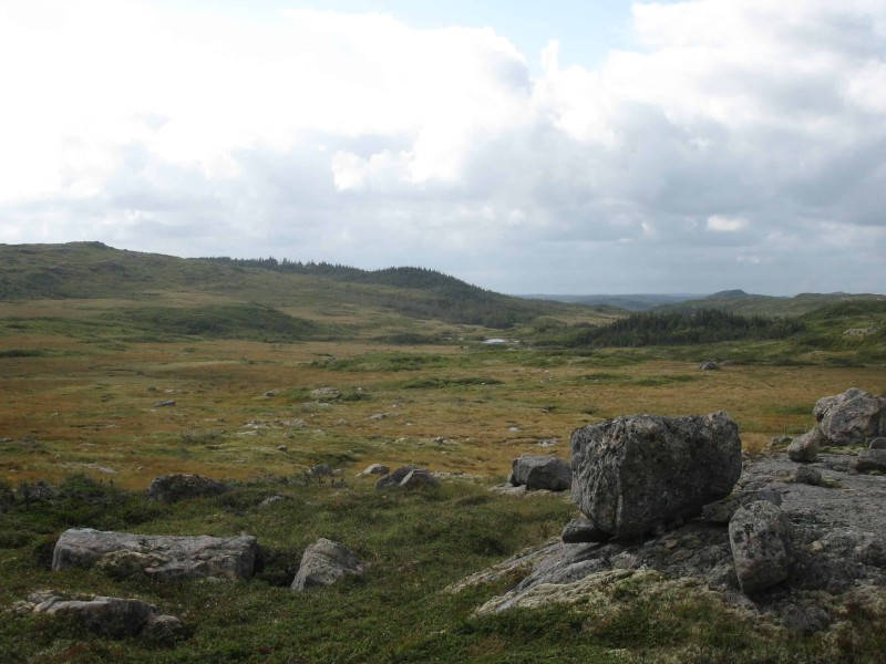
Just after two o’clock I broke out onto the barrens and entered the Avalon Wilderness Reserve proper. I rounded the southern end of a small pond on the border of the reserve and set a bearing for the next pond to the southeast. Map and compass would be my tools of navigation on this trip.

Looking north toward Chisel Hill (far right)
About mid-afternoon, my destination for the day came into view: Bloody Pond – a sheet of blue showing between some low hills in the distance. I was getting colder and hoped to find shelter for the night on its shores in the lee of a hill.
Not long before reaching Bloody Pond I happened upon an imposing erratic stone formation next to a gully. It was a huge outcropping of rock, jagged and cleft by years of freeze and thaw. Flaky lichens covered its oddly angled surfaces. Partridge berries grew in a depression created by the clefts. I climbed atop for a rest and a view. It seemed a ruined fortress where fairies had once held their ground.
Arrival at Bloody Pond
Moving westward I crested one of the many half-wooded hills in the area. Now Bloody Pond was directly below me. I had only to choose a camping place. I entered a small patch of marshy woods on the shore of the pond. It turned out to be one of those moose-bowers that I’ve frequently happened upon. Between large, widely-spaced coniferous trees the ground was covered with tall soft grass. Here and there, where moose had lain down to rest, the grass was flattened. Their muddy trails led into the secluded abode from the surrounding barrens. I imagined this as their shelter from the storms.

Fairy fortress
I camped that first night on the barrens next to the moose-bower. The wind continued to blow fiercely. The clouds lowered, bringing light rain. A nearly full moon lit the clouds from behind. Moonlight filtered through the thick and thin in swirling patterns as the clouds flew swiftly before the wind. I had supper in the tent and was content that despite my late start I had accomplished what I had intended for the day: I had arrived at Bloody Pond.
Tune back in Friday for Part 2 of this hike.

Related Articles
Trepassey to Hawke Hills (Day 7)
The finale of a journey in the Avalon Wilderness Reserve (in 7 parts)
Trepassey to Hawke Hills (Day 6)
The story of a camping trip through the Avalon Wilderness Reserve (in 7 parts)
Trepassey to Hawke Hills (Day 5)
The story of a camping trip through the Avalon Wilderness Reserve (in 7 parts)